

 Close Menu
Vaishali Pant

Travel
UTTARAKHAND: THE DEVBHOOMI STATE OF INDIA
 Vaishali Pant
Uttarakhand, originally Uttaranchal, is a state in India that is located in the country's northwest corner. The Indian state of Himachal Pradesh borders it to the northwest, the Tibet Autonomous Region of China to the northeast, Nepal to the southeast, and the Indian state of Uttar Pradesh to the south and southwest. The city of Dehra Dun in the northwestern part of the country serves as the country's capital.
Uttrakhand is also known as DEVBHOOMI- meaning the place of gods. It is the Devbhoomi state of India.
On November 9, 2000, Uttaranchal, India's 27th state, was formed out of Uttar Pradesh, and in January 2007, the new state was renamed Uttarakhand, which means "northern region," the area's original name. The total area is 19,739 square miles (51,125 square km). The population was 10,116,752 in 2011.
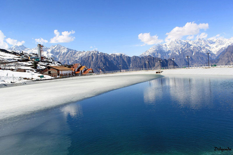
Snow-capped peaks, glaciers, steep valleys, roaring streams, magnificent lakes, and a few patches of dusty plains in the south characterise Uttarakhand's terrain. Uttarakhand is home to some of the world's tallest mountains. Nanda Devi (25,646 feet [7,817 metres]), India's second highest mountain, Kamet (25,446 feet [7,756 metres]), and Badrinath (25,446 feet [7,756 metres]) are among the most notable (23,420 feet [7,138 metres]).
Uttarakhand is separated into a number of physiographic zones that run parallel to one another from northwest to southeast. With elevations ranging from 10,000 to 25,000 feet, the northern zone, known as the Himadri, encompasses segments of the Zaskar and Great Himalaya mountains (3,000 to 7,600 metres). This zone contains the majority of the main summits. The Lesser Himalayas, also known as the Himachal, are located adjacent to and south of the Great Himalayas, with elevations ranging from 6,500 to 10,000 feet (2,000 to 3,000 metres); the zone comprises two linear ranges: the Mussoorie and the Nag Tibba. A section of the Siwalik Range lies to the south of Himachal Pradesh.
The Siwalik Range's southern edge combines with the Bhabar, a narrow bed of gravel and alluvium that connects to the southeast with the Tarai, a marshy area. The total elevations of Siwalik-Bhabar-Tarai range from 1,000 to 10,000 feet (300 to 3,000 metres). Flat-floored depressions, known locally as duns, such as the Dehra Dun, can be found south of the Siwaliks.
The state is drained by the Ganges (Ganga) system's many rivers. The Yamuna River and its biggest tributary, the Tons, create the westernmost watershed. The Bhagirathi and Alaknanda rivers, which merge to form the Ganges at Devaprayag, as well as the Mandakini, Pindar, and Dhauliganga, drain the region to the east of this basin.
The Gahrwal, which roughly corresponds to the state's northwestern half, and the Kumaun, which spans the state's southeast, have a multiethnic population dispersed among two designated geocultural zones. A substantial portion of the population is made up of Rajputs (different clans of landowning rulers and their successors), who include members of the indigenous Garhwali, Gujjar, and Kumauni groups, as well as a variety of immigration peoples. Nearly one-fifth of the population belongs to the Scheduled Castes (an official classification for those groups that have traditionally had a poor place under the Indian caste system); these individuals are known as Kols or Doms together. Scheduled Tribes, such as the Raji, who dwell close the Nepalese border (an official category encompassing indigenous peoples who fall outside the Indian social framework).
Source:
Click for the: Full Story
You might like


You Might Like this